Immerse into the field through an internship!
Andrew Adams, a MSPD student, with the City of Chesapeake, VA
Andrew Adams, a graduate student in the Master of Science in Planning and Development (MSPD, online degree), had an immense internship opportunity with the City of Chesapeake, VA. The internship built a strong foundation for him to learn how a municipal planning department operates and functions.
Although the MSPD is an online degree, students can earn internship credits from onsite training through internships where they live. The course credits are available for one, two, or three academic credits, depending on the completed internship hours. For more information, check out the internship information on our website.
Read a portion of his internship reflection report below.
“The internship was roughly comprised of two parts, with the first half involving meetings with all the staff members of the departments, including the Director of Planning. The second half consisted of individual research and study regarding several projects in the City of Chesapeake.
Like many other departments, The City of Chesapeake Planning Department is comprised of three sub-departments, including current planning, comprehensive planning, and community development. A valuable administrative team aids all three departments in administrative duties. My supervisor was the current planning administrator therefore, I was exposed more so to the current planning sub-department. Arguably, the most important topic learned, and one that took the longest to grasp, was the inner-workings of the application process. Rezonings, Use Permits, Subdivision/Site Plan Review, and Text Amendments were the common applications received and required a step-by-step process from application submittal all the way to City Council hearing if a public hearing is required. Staff Planners are the project managers of these applications and see that all required documents are correct and present, staff reports are complete, proffers (if any) reflect the goals and needs of the city, and the application has moved through the required other municipal departments. I was fortunate to attend a planning commission meeting. Witnessing the meeting structure and reiterating the application process was a great experience.
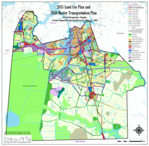
Adopted 2035 Land Use Plan With 2050 Master Transportation Plan
During my internship, I met with several members of the current planning department. One valuable meeting was with a subdivision and site plan review planner. Subdivision review is a meticulous process that requires review of every setback, easement, and individual lot, to name a few, all comply with the subdivision ordinance listed in the zoning code. Planned Unit Developments and Conservation Cluster Developments are variations of the traditional subdivision that allow for greater flexibility in lot size in exchange for greater open space. Another planner I met with is the city liaison for the Chesapeake Bay Preservation Area (CBPA). Chesapeake consists of a municipal board that oversees and regulates current and future land parcels inside the CBPA zone. Areas inside this zone have special requirements due to their location in environmentally sensitive areas. This department does have a dedicated GIS staff member who is responsible for the constant update of the GIS land use map as well as GIS illustrations for staff reports and other presentations. We met and went over the GIS tools available to planners and how to apply the various layers to achieve the sought-after information. After some brief practice, I was identifying parcels, adding overlays/study areas, and, most importantly, being able to look up the status of current projects. Overall, my time with the current planning team revealed how important details and deadlines are to ensure applications are efficiently moving through the process.
The comprehensive team with this municipality deals with long-term plans and studies. The adopted comprehensive plan is huge part of the team and dictates many decisions long term and short term. The department also uses a Land Use Master Plan Map through 2035, which, although not binding, is very important in guiding growth. Chesapeake is grouped into 3 overlays – urban, suburban, and rural. All 3 have different development standards depending on the parcel’s location. A key goal of the rural overlay is to preserve open space and natural resource areas. Surrounded by the Great Dismal Swamp and the Intercoastal Waterway, the city has implemented the Open Space and Agricultural Preservation Program OSAP. This program purchases development rights in exchange for a preservation easement on their property.
As in most other municipalities of this size or bigger, a series of studies and special emphasis areas are in constant motion. Greenbrier is part of the city heavy in commercial retail, industrial parks, and medium-density residential. Due to the changing nature of current retail, an individual consulting group was hired to assess the current state of Greenbrier and provide recommendations for future plans. Greenbrier also has a newly built, vertical mixed-use development, which the City wants to expand upon. A public outreach meeting was conducted and provided excellent feedback on what the public would like to see as we downsize and phase out some parcels of big box retail.
Home to an abundance of waterfront property due to the city’s location on the Intercoastal Waterway, much opportunity exists for industrial, residential, and commercial on these waterfront properties. Although much of the developed waterfront land is currently industrial, sea-level rise and flooding is a never-ending concern, and an independent study is currently underway to assess the current land use and future needs. This waterfront area has been utilized for shipping purposes since the 1700s, and its proximity to military bases and shipyards make it a prime location even though container ships cannot pass through to points south.
Last semester, I took the Growth Management course with Professor Richter. This internship really tied together the theories learned from the course to growth management strategies implemented in the City of Chesapeake. The city implements two major tools to control and manage growth, which include overlay districts designating land use and the Public Utility Franchise Area PUFA. The city PUFA map delineates where water and sewer are permitted to be expanded and requires a tough and lengthy process to allow utility expansion. This strategy has been successful in preventing unorganized growth in the city’s rural overlay district. Recently, a multi-hundred-acre industrial park was approved by City Council in the Rural Overlay. In addition to a conditional rezoning approval, a PUFA expansion was passed as well. This application received fierce opposition from nearby residents who cited that the rezoning and utility expansion conflicted with the growth management strategies outlined in the comprehensive plan. However, the City Council ruled in favor, citing that this created a “unique economic opportunity” and the economic benefits outweighed the environmental negatives.
The last half of the internship focused on a zoning ordinance text amendment project that I worked on with the oversight of a senior planner. Planned Unit Developments or PUD are developments that allow case-by-case discretionary flexibility from standard zoning ordinances. This development criterion is afforded to all zoning uses, including industrial, commercial, and residential, and also includes urban mixed-use. A great tool for planners is to examine other municipalities’ zoning codes, and I found our planned development language was incredibly restrictive. Minimum acreage and permitted overlay districts were addressed in the text amendment to allow more opportunities for PUD development. There is a current initiative to promote mixed-use, pedestrian-friendly with more efficient development, and allowing PUDs on smaller parcels with fewer prerequisites fits this initiative. This project also showed how restrictive zoning practices can hinder goals and objectives and that, often, the less is more mindset can benefit a successful municipality.
This opportunity with the City of Chesapeake was extremely beneficial in furthering my education and learning how a municipal planning department operates. The entire staff was more than kind and helpful, and I never felt like I was a burden. It also solidified areas of planning I find of interest and how I want to focus my studies. Long-range planning is extremely interesting and beneficial to how a municipality is set up for the future. My time with the comprehensive team learning about land conservation, transportation planning, fiscal impact, economic development, long-range planning, and special area focused studies was extremely interesting. Also, I was able to dive into the world of urban design. This specialized field defines what a city is and will become. Unfortunately, good urban design is often neglected throughout residential and commercial districts, leading to monotony and ugly cities lacking character. Furthermore, this internship gave me a direction for my professional paper. I feel zoning reform is the underlying root of many municipality issues, and zoning flexibility is the major key to long-range plans coming to fruition. Fighting inclusion, lack of monotony, parking minimums reform, and smart growth practices are four areas I want to focus on and good zoning practices allow these four categories to make municipalities the best versions of themselves. All in all, this was a great internship, and I thank the City of Chesapeake Planning Department for this opportunity.”